Kapyl (Kapyl’)
 |
 |
The postal codes for Kapyl are 223910 and 223927.
Kapyl, first mentioned in 1274, was a walled town that was noteworthy by the 14th century, and is listed in the atlas of Ortelius of 1574. During the 14th century the town was part of the Grand Duchy of Lithuania. In 1395 it came into the possession of Prince Vladimir Olgerdovich and his heirs, the Olelkovich family, where it remained until 1612. Kapyl was part of the dowry of Zofia Olelkowicz Słucka and was one of the seven fortified towns left to her husband Janusz Radziwill upon her death in 1612. Kapyl was attacked by the Tatars numerous times and was sacked on at least one occasion during the 16th century.
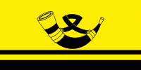
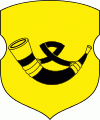
On August 27, 1652, Kapyl received the Magdeburg Law and gained its own seal, a coat of arms depicting a hunting horn on a gold field. With this privilege came the right to hold fairs and weekly auctions. During the 16th century weaving became established in the town, including the production of velvet. Six guilds came into existence as a result of the growth of the weaving industry.
After the Second Partition of Poland in 1793 Kapyl became part of the Russian Empire. From 1832 it became a personal holding of Prince Wittgenstein. During the 19th century local businesses included a brewery, 2 water mills, and 6 shops. Other local institutions included 3 schools, churches (including a Calvinist church), and 2 Jewish synagogues.
Towards the end of the 19th century Kapyl had over 350 houses and over 2000 inhabitants. At that time a majority of the town's population was Jewish. By 1900 the Jewish population was 2,671.
In 1924, Kapyl became the capital city of the Kapyl District.
During World War II the Slutsk-Kapyl area was the subject of a German military operation code-named Erntefest II (Harvest Festival) which ended in February 1943. Although ostensibly aimed at suppressing the activities of Soviet partisans in the area the operation resulted in the deaths of 2,325 of the local inhabitants (against the loss of six German soldiers), which can only be characterized as a campaign of genocide and terror.
One of Kapyl district's major architectural monuments is a 19th-century church in the town itself.
Map - Kapyl (Kapyl’)
Map


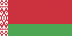
Country - Belarus
 |
 |
| Flag of Belarus | |
Until the 20th century, different states at various times controlled the lands of modern-day Belarus, including Kievan Rus', the Principality of Polotsk, the Grand Duchy of Lithuania, the Polish–Lithuanian Commonwealth, and the Russian Empire. In the aftermath of the Russian Revolution in 1917, different states arose competing for legitimacy amid the Civil War, ultimately ending in the rise of the Byelorussian SSR, which became a founding constituent republic of the Soviet Union in 1922. After the Polish-Soviet War, Belarus lost almost half of its territory to Poland. Much of the borders of Belarus took their modern shape in 1939, when some lands of the Second Polish Republic were reintegrated into it after the Soviet invasion of Poland, and were finalized after World War II. During World War II, military operations devastated Belarus, which lost about a quarter of its population and half of its economic resources. The republic was redeveloped in the post-war years. In 1945, the Byelorussian SSR became a founding member of the United Nations, along with the Soviet Union.
Currency / Language
| ISO | Currency | Symbol | Significant figures |
|---|---|---|---|
| BYN | Belarusian ruble | Br | 2 |
| ISO | Language |
|---|---|
| BE | Belarusian language |
| RU | Russian language |